
|
Getting your Trinity Audio player ready...
|
Hurricane Polo strengthened rapidly Tuesday off Mexico’s Pacific coast, bringing flooding and mudslide risks to several states.
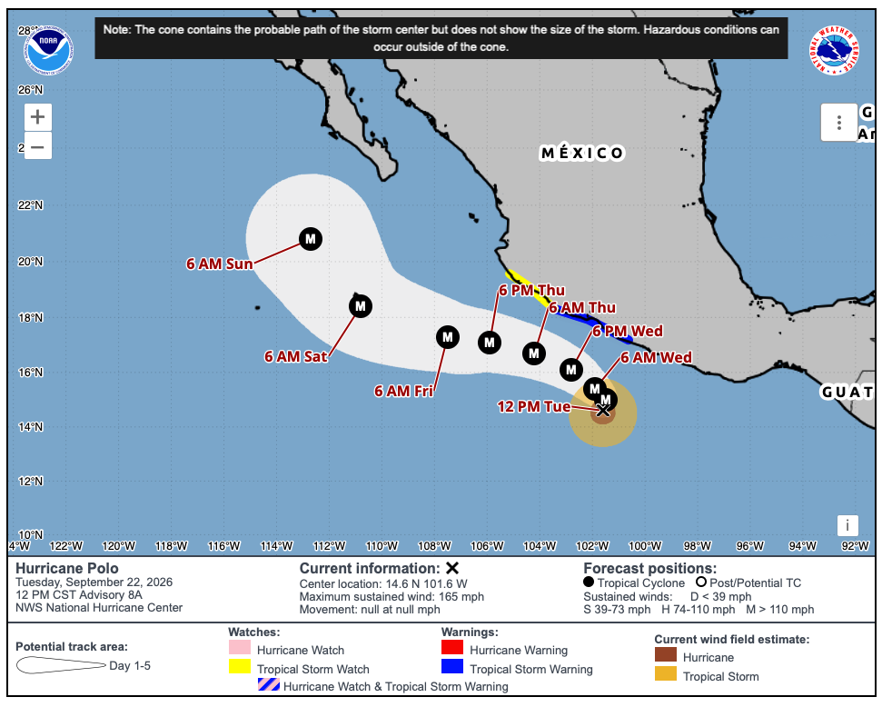
The storm reached Category 5 strength Tuesday as it remained offshore of southwestern Mexico, with maximum sustained winds of 165 mph and a minimum central pressure of 920 millibars, according to the U.S. National Hurricane Center. Polo was nearly stationary about 215 miles south of Zihuatanejo and was expected to remain offshore while moving slowly generally west-northwestward over the next several days.
The hurricane center said Polo was expected to remain near the southwestern Mexican coast through the middle of the week, with tropical storm conditions expected along part of the coastline. A tropical storm warning was in effect from Tecpan de Galeana to Punta San Telmo, while a tropical storm watch extended westward from Punta San Telmo to Playa Perula.
The principal threat to land is heavy rainfall. The National Hurricane Center forecast 3 to 6 inches of rain, with isolated totals of up to 8 inches, across coastal Guerrero and Michoacán through Thursday. Coastal areas of Oaxaca, Colima and Jalisco could receive 2 to 4 inches. The rainfall could trigger life-threatening flooding and mudslides, particularly in mountainous terrain.
Mexican authorities temporarily suspended classes in some coastal areas as the storm approached, while the Mexican Navy closed ports in Guerrero and Michoacán as a precaution. The Associated Press reported that authorities were also warning residents and fishermen about dangerous conditions as Polo moved offshore.
Polo’s rapid strengthening has made it the third Category 5 hurricane of the eastern Pacific season, following Genevieve and Lowell. Category 5 is the highest classification on the Saffir-Simpson Hurricane Wind Scale and applies to storms with maximum sustained winds of at least 157 mph.
Forecasters were also monitoring Tropical Storm Odalys farther west in the Pacific, which was expected to strengthen into a hurricane. In the Atlantic, Tropical Depression Fay was weakening southwest of the Azores.
Sources: Information attributed to the U.S. National Hurricane Center, NOAA and The Associated Press, with additional reporting from the sources provided in the research.