
|
Getting your Trinity Audio player ready...
|
Hurricane Polo has returned to Category 5 strength off Mexico’s Pacific coast. Its rainbands are bringing rain inland.
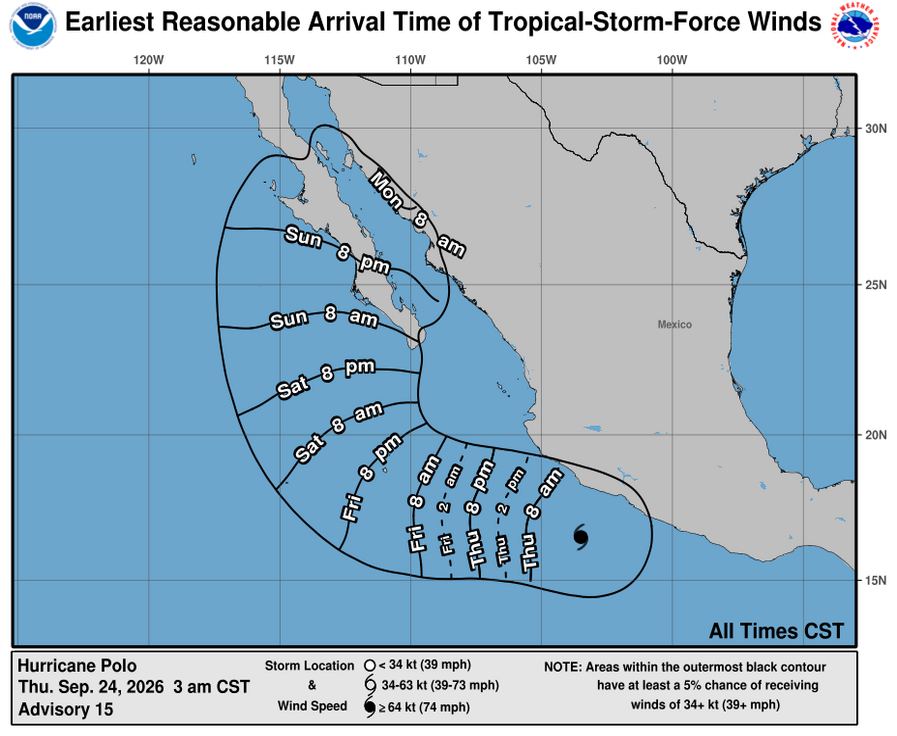
Hurricane Polo regained Category 5 strength early Thursday as it churned offshore of southwestern Mexico, with its outer rainbands spreading heavy rain across coastal areas, according to the U.S. National Hurricane Center. The storm was about 130 miles southwest of Zihuatanejo and 200 miles southeast of Manzanillo at midnight Thursday, moving northwest at 7 mph with maximum sustained winds of 160 mph.
Polo has repeatedly fluctuated in strength since rapidly intensifying earlier in the week. The hurricane briefly reached winds of about 180 mph before weakening to Category 4 strength Wednesday, then strengthened again. The National Hurricane Center said additional near-term strengthening was possible and expected Polo to remain a powerful major hurricane for the next several days.
The hurricane was forecast to remain offshore rather than make a direct landfall, but its proximity to Mexico’s Pacific coast was producing dangerous conditions. Heavy rainfall was expected across parts of southwestern Mexico, with the threat of flash flooding and mudslides particularly significant in mountainous areas. Tropical-storm-force winds and dangerous ocean conditions were also affecting coastal communities as Polo passed offshore.
Mexican authorities had taken precautionary measures along parts of the Pacific coast as the storm approached, including suspending activities in some areas and closing ports in Guerrero and Michoacán. Beaches were largely emptied as residents and visitors prepared for heavy rain, strong winds, large waves and hazardous surf conditions.
Polo is also part of an unusually active period in the eastern Pacific, where several significant systems have developed. The hurricane became the third Category 5 storm of the eastern Pacific season, following hurricanes Genevieve and Lowell, according to reporting based on National Hurricane Center data.
At the same time, Tropical Storm Nolo was approaching Hawaii farther west across the Pacific. As of Wednesday night, Nolo had maximum sustained winds of 45 mph and was about 295 miles south of South Point, Hawaii. The National Hurricane Center said Nolo was expected to strengthen into a hurricane Thursday and could become a major hurricane by the weekend, while a hurricane watch remained in effect for Hawaii County.
Sources: National Hurricane Center, Associated Press, CBS News, NPR and Local 10.